A permanent, searchable record of every property's condition, and what changed.
Stop reconstructing when damage happened from photos and documents scattered across drives: ask any question about any asset and get a sourced answer with the date.
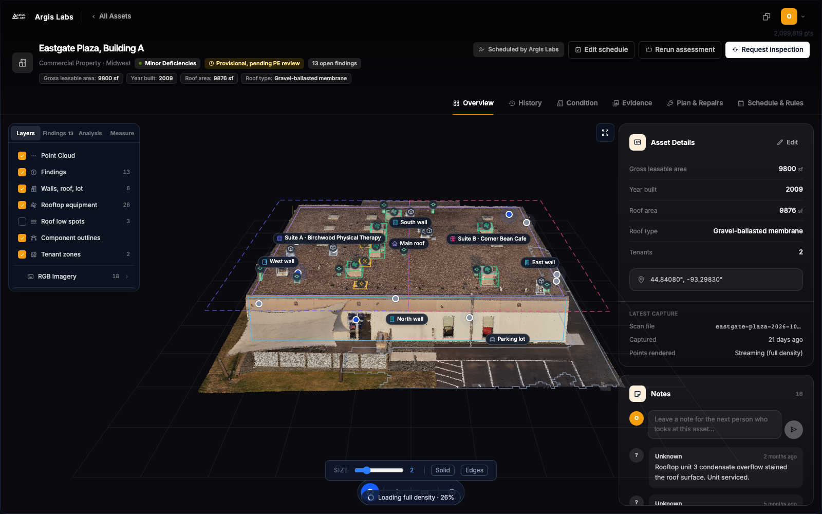
What the owner can do with the record.
Screens from the Argis Labs app. Findings are decision support. They are not a seal or a compliance determination.
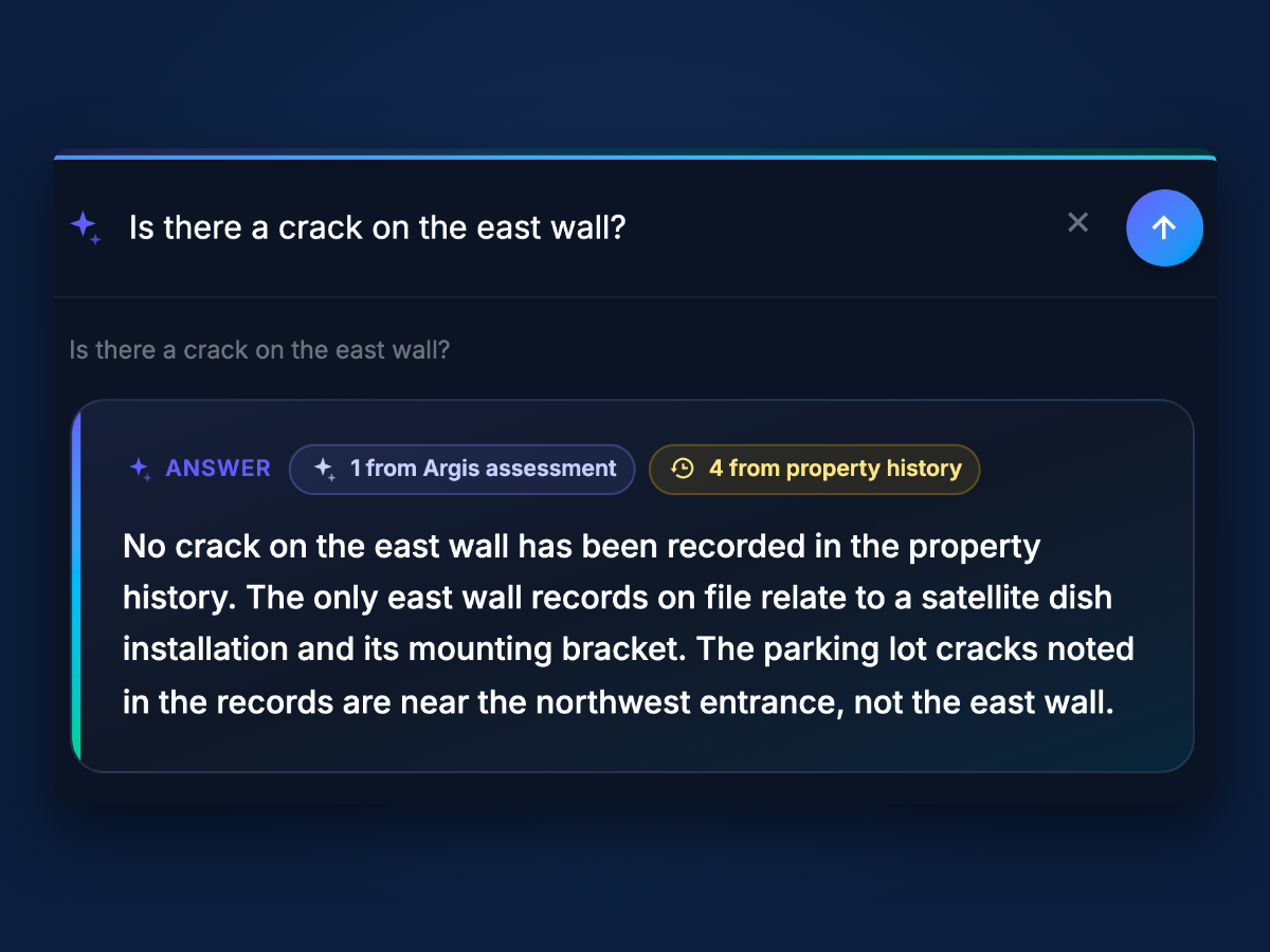
Answer a question about any asset
Ask "Is there a crack on the east wall?" in plain English and get a sourced yes or no. The answer lists the dated records it used.
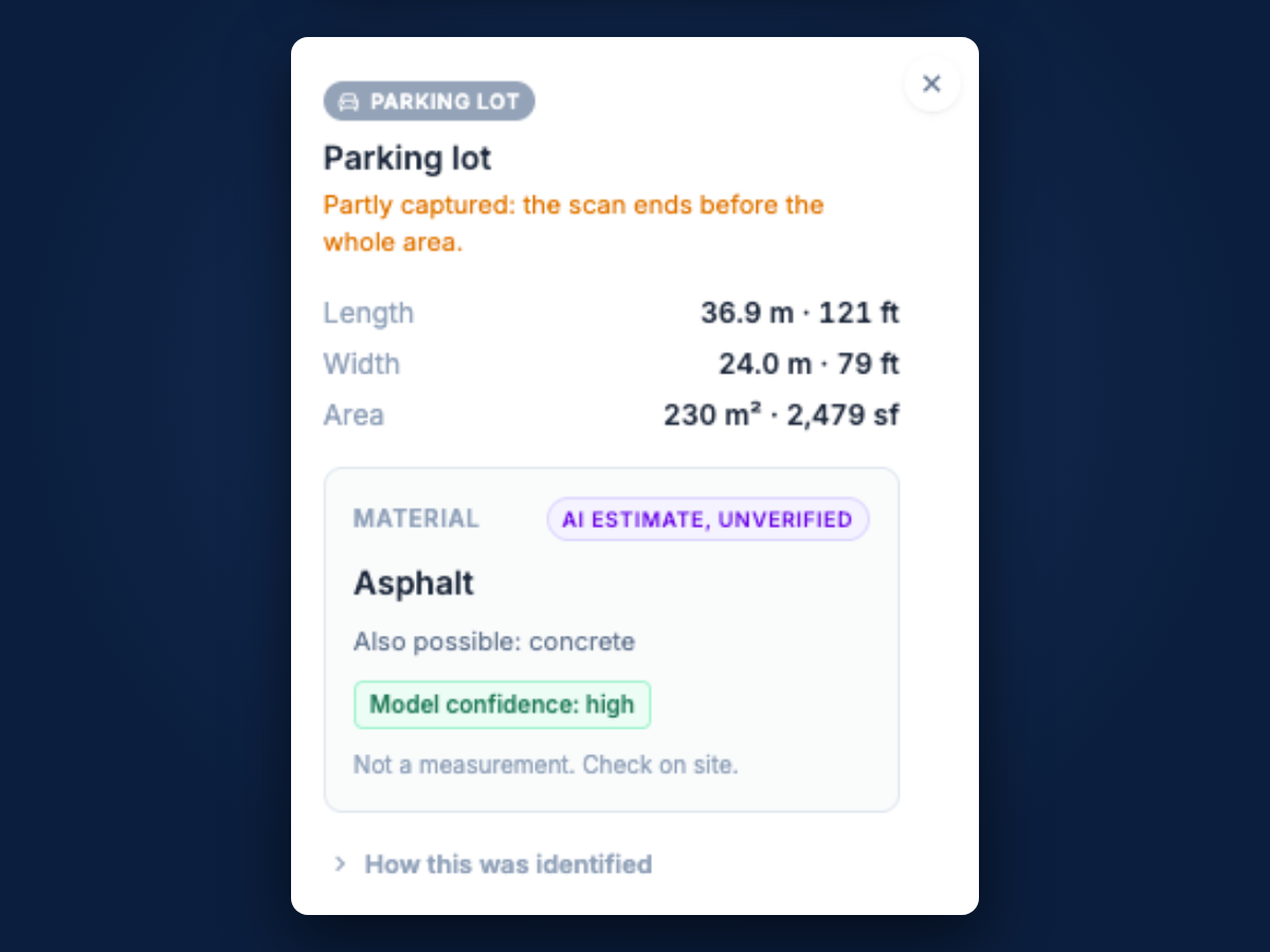
See the photo behind every finding
Each finding carries the photos behind it and is labeled provisional pending professional engineer review.
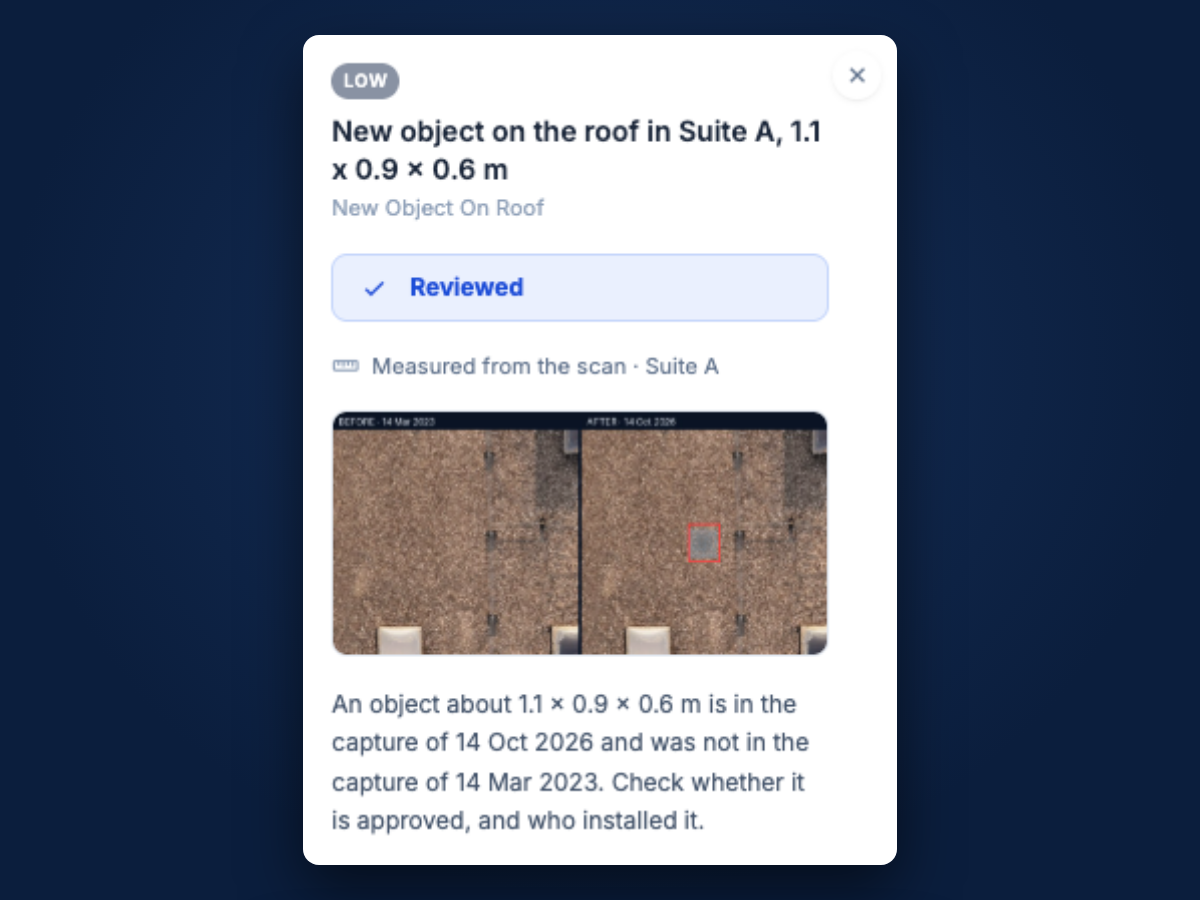
See when something changed
Before and after photos between two dated scans, so "when did that appear" has an answer.
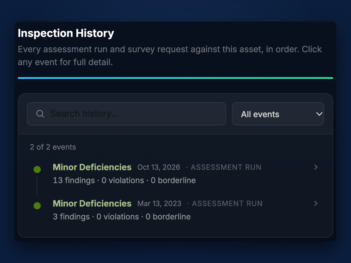
Read a multi-year history
A multi-year condition timeline assembled per asset, not per document.
Condition history lives in too many places.
Photos scattered across drives
Each inspection arrives as its own report and its own folder. Answering "what did this wall look like two years ago" means finding the right drive first.
Findings that don't connect to action
A report still has to be translated into work orders, and it can be hard to tell later whether the repair was actually made.
Records that don't carry forward
When each inspection is a separate document, comparing a property's condition over time means starting from scratch.
From first scan to work order closed.
- 01
Discovery call
Tell us the properties and what you need to know. We scope the scans, the deliverables, and the price.
- 02
We collect and build
Licensed FAA Part 107 pilots scan the property on site. We build the digital twin and run the assessment. We need site access and a contact on site from you.
- 03
You assess and act
Search the twin, review findings with photo evidence, and turn them into work orders you track to done. Every later scan is compared against this one.
Everything in one record.
Scans, twin, findings, history, and work orders live together, per property.
Digital twin
A measurable 3D model of the property built from LiDAR and imagery. Look at any wall, roof, or lot from any angle without being on site.
Condition findings with evidence
Each finding carries its photos and measurement, located on the model, and is provisional until a professional engineer reviews it.
Change detection
Compare any two dated scans and see what changed, with before and after images.
Work orders and tracking
Turn a finding into a work order, integrate with the system your team already uses, and track it through to completion.
Georeferenced locations
Positioning data ties every finding to a place a crew can find again.
Exportable deliverables
The twin, findings, and history, exported in the formats your team and your engineers need.
Regulatory and compliance reporting
What the record gives an owner when a lender, insurer, or regulator asks about a property.
Documented condition at a point in time
Every assessment is stored as a dated snapshot, so you can show what a property looked like on a given day.
An audit trail of each assessment and its date
Each assessment, finding, and change is recorded with its date, so the history of a property can be traced end to end.
Evidence structured for professional engineer review
Findings and photo evidence are organized so a licensed engineer can review them and reach their own conclusions.
Findings are provisional pending professional engineer review. We do not seal drawings or certify compliance.
Start with a pilot. Then one annual fee.
Pilot: $4,500 for one property
Or $3,500 per property for up to three. Includes data collection, the digital twin, condition assessment, and exportable deliverables.
Pilot credit
50% of the pilot fee is credited against year-one fees if you sign a portfolio agreement covering 5 or more properties within 90 days.
Annual: $0.10 per sq ft per year
Includes one assessment per year, with the twin, findings, search, change detection, and work orders with tracking. Extra scans are charged per assessment.
Example: 200,000 sq ft
$20K per year, against $8K-$15K for a one-time property condition assessment (PCA) that gives you a single report and no record to build on.
A pilot covers one to three properties: the twin, a condition assessment, and exportable deliverables for each. It is for owners and operators of multi-property commercial portfolios deciding whether to keep their condition records in one place.
The twin is the product.
The value is the record that builds up for each property: the twin, the assessment of it, and the work orders, in one place that carries forward.
One record per property
Every assessment adds to the same property record, so history accumulates instead of resetting with each report.
Collection is included
We run the on-site scans with licensed FAA Part 107 pilots.
Findings become work
Findings turn into work orders and are tracked to completion, so the record shows what was fixed and when.
Not an engineer of record
Findings are provisional pending professional engineer review. We do not seal drawings or certify compliance.
- Commercial property
Shopping centers, retail, office, mixed-use, master-planned communities - Communication towers
Structural inspection, mounts, compliance reporting - Utility-scale solar
Thermal and visual inspection, dated record per array
Bring us a property.
A call on what you manage, how you track condition today, and what a pilot would cover. You leave with a scope and a price.
- A pilot starts at $4,500 for one property.
- 50% credited toward year one if you sign for 5 or more properties within 90 days.
A pilot covers one to three properties: the twin, a condition assessment, and exportable deliverables for each. It is for owners and operators of multi-property commercial portfolios deciding whether to keep their condition records in one place.
Who is building this.
Argis Labs was founded by Zac Brown (CEO) and Alberto Carrazco (co-founder), who has hands-on tower inspection experience. Before this, the team shipped production software at SumUp, Nextiva, StrongMind, and CareRev, and Zac founded and ran GiveKit to nationwide nonprofit coverage. We are a software company. The value is the record that accumulates for each property, and the assessment of it.
Questions owners ask
What is Argis Labs?
Argis Labs is a platform that keeps a permanent, searchable record of each property's condition. Each property has a digital twin that is assessed over time, with work orders tracked through to the fix. The record stays with the property, so each new assessment is compared against the last one.
What do I receive?
A digital twin of each property, condition findings with photo evidence, change detection between dated scans, and work orders tracked through to completion, plus exportable deliverables. Each finding is labeled provisional until a professional engineer reviews it.
Which types of property does Argis Labs cover?
Three: commercial property (shopping centers, retail, office, mixed-use, master-planned communities, covering the whole building, the lot, and the items around it), communication towers, and utility-scale solar.
Is Argis Labs a drone inspection service?
No. Data collection is part of the platform, but the value is in the twin, the assessment of it, and the record that builds up for each property, plus work orders and tracking.
How does pricing work?
A pilot is $4,500 for one property, or $3,500 per property for up to three. It includes data collection, the digital twin, condition assessment, and exportable deliverables. 50% of the pilot fee is credited against year-one fees if you sign a portfolio agreement covering five or more properties within 90 days. After the pilot, one annual fee covers the software and a set number of on-site scans per year.
Does Argis Labs provide certified engineering conclusions?
No. Every finding is labeled provisional pending professional engineer review. Argis Labs does not provide professional seals, regulatory compliance determinations, or engineering approval. If a decision needs a licensed engineer, the findings and photo evidence are structured so that engineer can review them.
Where is Argis Labs available?
Anywhere in the United States.
Which property should we start with?
Tell us what you manage and what you need to know about it.
Book a discovery call